State of India
Bihar
Reported
Last updated 11 Oct 2026
Bihar is a state in eastern India with its capital at Patna. The 2011 Census recorded a population of 104,099,452 over an area of about 94,163 km².
Capital
Patna
Area
94,163 km²
Population
104,099,452
Year 2011 · Census of India 2011
Density
1,105.5 /km²
Calculated
Districts
38
As of Jan 2025
Formed
22 March 1912
Separated from the Bengal Presidency in 1912 (Bihar Diwas)
Official language(s)
Hindi; Urdu (second official language)
Overview
Bihar lies in the eastern Gangetic Plain and is one of India's most densely populated states. The Ganga flows from west to east across the state, joined by tributaries such as the Son, Gandak and Kosi.
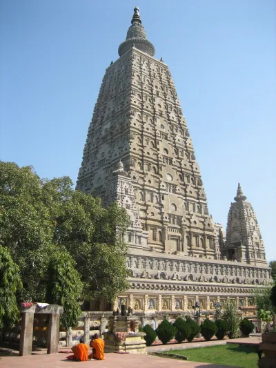
Bihar has a long and influential history: ancient Pataliputra (modern Patna) was the capital of the Maurya and Gupta empires, Bodh Gaya is where the Buddha is believed to have attained enlightenment, and the remains of Nalanda Mahavihara are a UNESCO World Heritage Site.
Districts of Bihar
The district directory for Bihar has not been published yet. Bihar has 38 districts (as of January 2025).
Major cities & towns
All citiesHistory & formation
Few places in the world have a history as deep as Bihar's. Ancient Magadha, with its capital at Pataliputra (modern Patna), was the heart of the Maurya Empire under Chandragupta Maurya and Ashoka, and later of the Gupta Empire. Vaishali is regarded as one of the earliest republics, Nalanda and Vikramshila were great international centres of learning, and Bihar is where the Buddha attained enlightenment and Mahavira, the 24th Jain Tirthankara, was born.
In modern times Champaran was the site of Mahatma Gandhi's first satyagraha in India in 1917. Bihar was separated from the Bengal Presidency in 1912 – celebrated each year on 22 March as Bihar Diwas – and Jharkhand was carved out of its southern districts in 2000.
Geography
Bihar lies almost entirely in the fertile Gangetic plain. The Ganga flows from west to east, dividing the state into north and south. Rivers from the Himalaya such as the Gandak and the Kosi – long called the "sorrow of Bihar" for its floods – join from the north, while the Son joins from the south. The Valmiki Tiger Reserve lies in the far north-west along the Nepal border.
Rivers, mountains & protected areas
Climate
Summers are hot, the monsoon brings heavy rain between June and September, and winters are cool and foggy.
Economy, agriculture & industry
Agriculture employs most people, with rice, wheat, maize, lentils, makhana (fox nut) and litchi from Muzaffarpur among key products. Tourism around the Buddhist circuit – Bodh Gaya, Rajgir, Nalanda and Vaishali – is growing.
Culture, festivals & cuisine
Hindi and Urdu are official languages, and Bhojpuri, Maithili and Magahi are widely spoken. Chhath Puja, dedicated to the Sun god, is the state's most important festival. Madhubani (Mithila) painting, Sikki grass craft and Bhagalpur silk are celebrated crafts, and litti-chokha is the signature dish.
State symbols
State symbols for Bihar are awaiting editorial verification. We only list symbols confirmed by an official source.
Legislature & representation
Details| Legislature | Bicameral |
|---|---|
| Legislative Assembly (Vidhan Sabha) seats | 243 |
| Legislative Council (Vidhan Parishad) seats | 75 |
| Lok Sabha constituencies | 40 |
| Rajya Sabha seats | 16 |
Seat figures as of January 2025 · source.
Tourist places & heritage
More
Sources & references
- Census of India 2011 – state population and area – Office of the Registrar General & Census Commissioner, India (2011) , retrieved 10 Oct 2026 – Population and area Reported
- Election Commission of India – delimitation and seats – Election Commission of India , retrieved 10 Oct 2026 – Lok Sabha and Assembly seat counts Reported
Articles about Bihar
All articles
Rivers, Mountains and Lakes
The Ganga: Course, Tributaries and Importance
Follow the Ganga from its Himalayan source to the Bay of Bengal, and learn why it matters for agriculture, ecology and c...